The Importance of HRIA-Mitigations

Under The Heritage Property Act of Saskatchewan, archaeological sites are protected because they offer cultural and scientific awareness into Saskatchewan’s past that can be studied and shared with the people of Saskatchewan through our education system and museums. In Saskatchewan, we have over 13,000 years of human occupation (in comparison the Pyramids of Egypt are approximately 5,000 years old) and although we do not have pyramids or temples, we do have archaeological sites that have arguably just as much scientific and cultural value even if they aren’t as noticeable on the landscape. This is why Heritage Resources Impact Assessments (HRIAs) are important.

The Heritage Conservation Branch (HCB) determines if a HRIA is required for developments in Saskatchewan. If a HRIA is required, it is the Proponent’s responsibility to hire a professional archaeologist to assess the proposed development to determine if any archaeological sites are in potential conflict. If an archaeological site is discovered in conflict with the Project, it is the archaeologist’s job to evaluate the significance of the archaeological site and to determine suitable mitigation measures. Avoidance is often recommended as a suitable mitigation method; however, in some instances avoidance cannot be maintained and an excavation is required in order to extract as much information as possible before the Project can proceed.

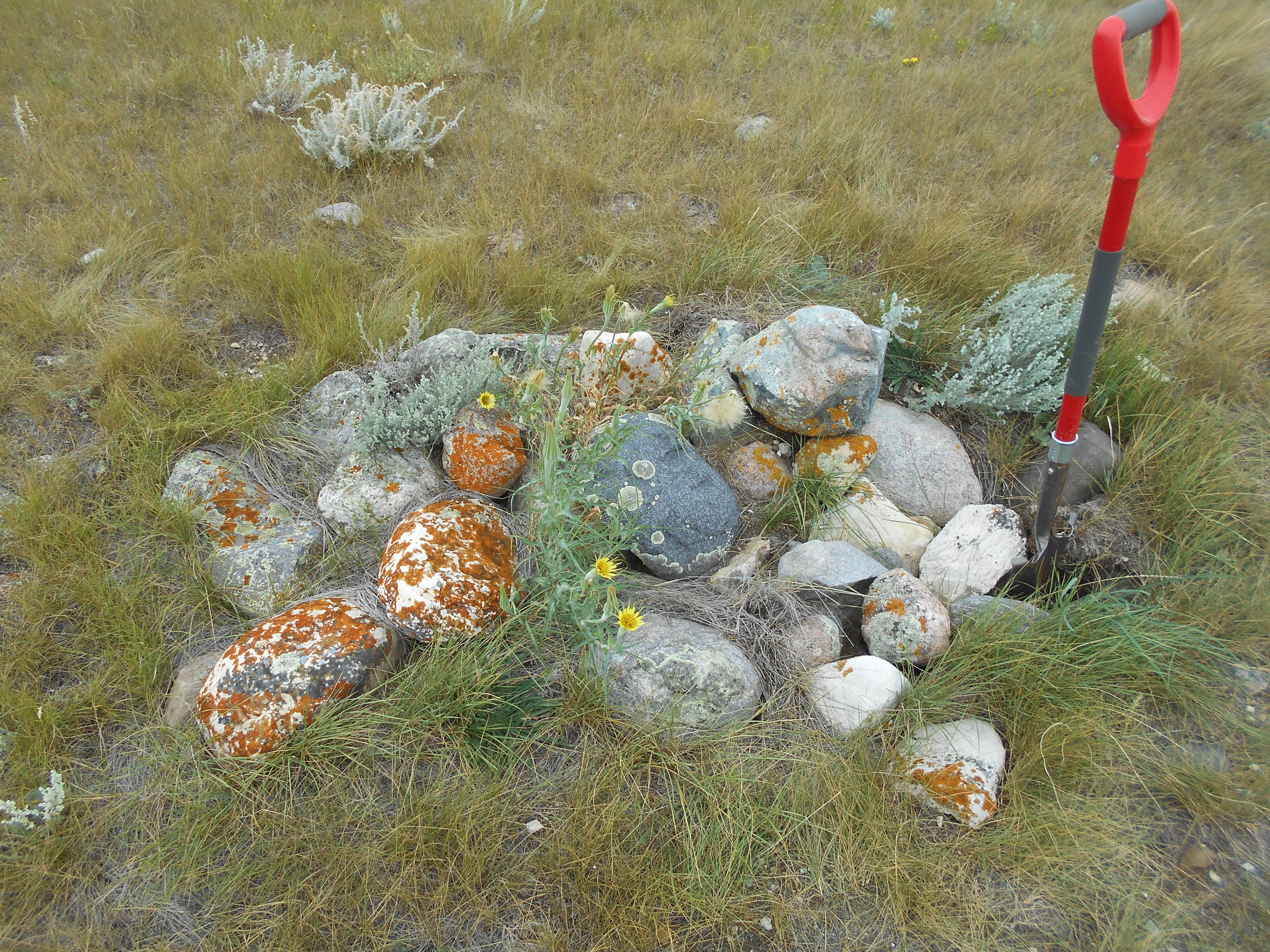
As an example, a Precontact Period stone cairn (human made rock pile) was discovered on top of a prominent hill with views in all four cardinal directions. On the surface, the stone cairn measured approximately 1.5 m by 2 m and consisted of at least 25 cobbles (Photo 1). The stone cairn originally appeared to be a simple geographical marker on the landscape, since the stone cairn was visible from at least 1 km away and offered excellent views of the surrounding landscape. Since the stone cairn could not be avoided, the stone cairn was fully excavated to learn as much as we can about the structure and the function of the feature before it was destroyed.

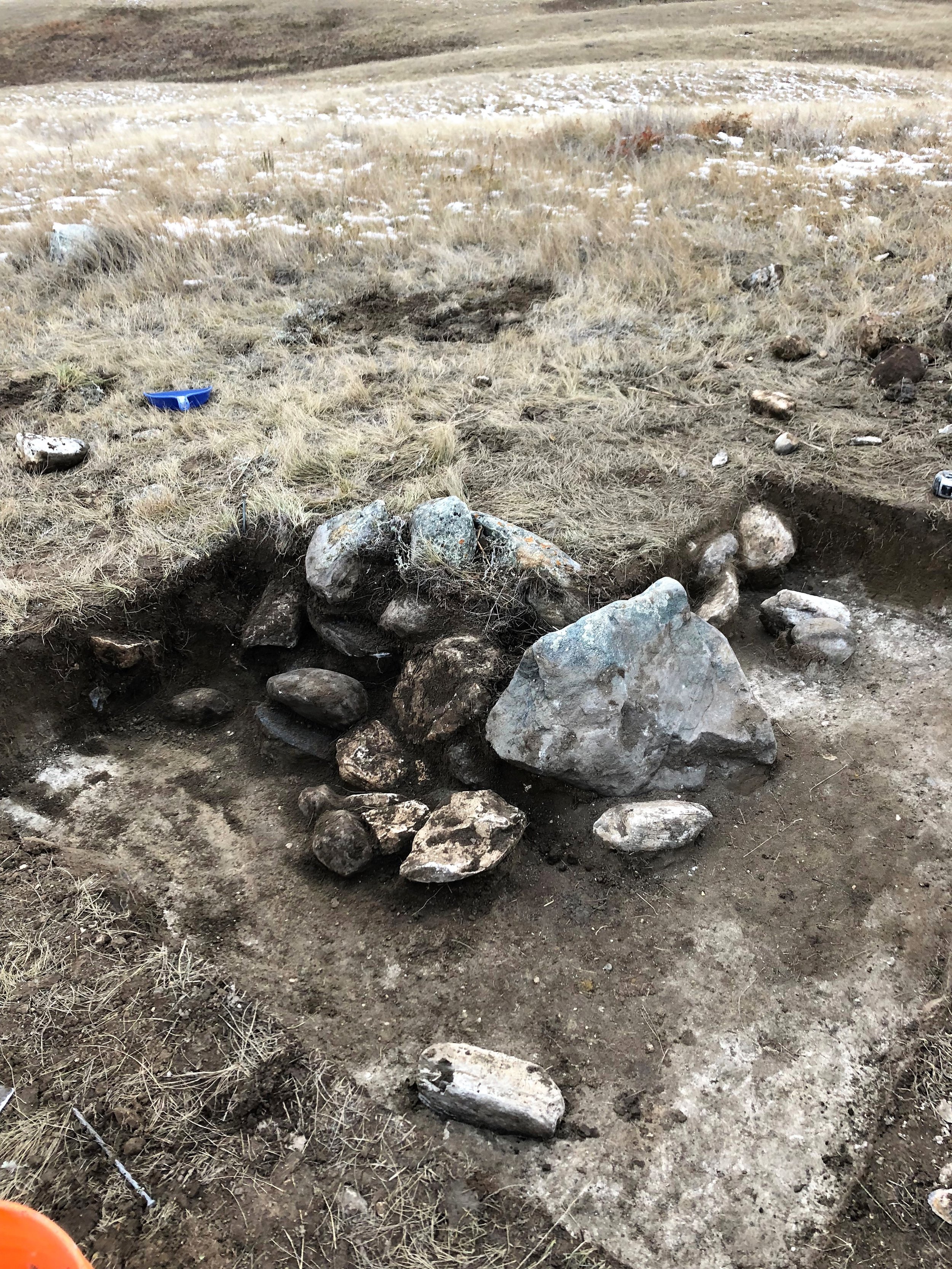
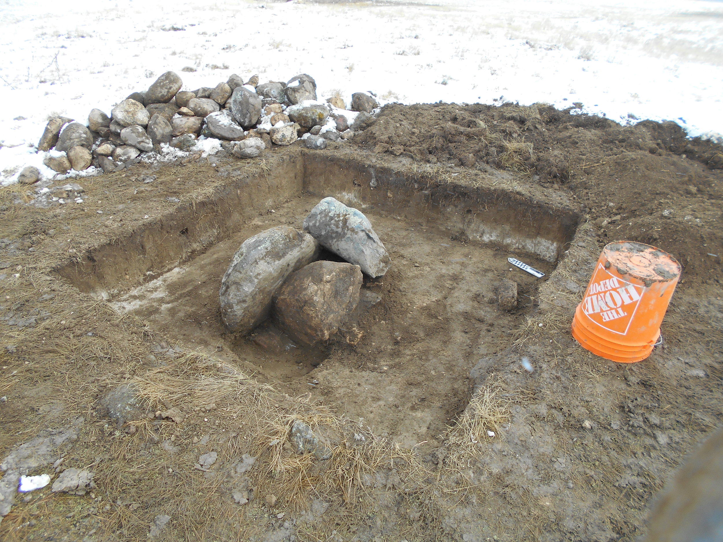
The stone cairn’s size after complete excavation measured 2 m by 2 m, extended to 40 cm below the ground surface, and consisted of approximately 75 to 100 cobbles with 3 large boulders forming the centre of the structure (Photos 2 and 3). A total of 129 artifacts were recovered from the stone cairn structure that included a projectile point dating to the Late Precontact Period (1,200 to 550 years BP). It was determined that the stone cairn was utilized as a cache as the 3 boulders discovered in the center of the structure were positioned in such a way as to create a small cavity that is easily accessible from the top and lined with cobbles on the bottom. No artifacts were discovered within the cache cavity.

On the Prairies, Precontact Period stone cairns are rarely excavated. This is primarily a result of old theories that suggest stone cairns are burial sites – which, in some rare cases they are. Therefore, archaeologists almost always recommend that Precontact stone cairns are avoided by all developments; however, when given the opportunity, archaeological excavations (a HRIA-Mitigation) allow us to further study and interpret the functions of stone cairns. In this particular case, the excavation of the stone cairn suggested that it was built for and used as a cache – a function not typically seen on the Prairies, adding scientific and cultural value to archaeology in Saskatchewan.

Working Closely with Saskatchewan’s Rural Municipalities

We’ve been receiving a lot of calls from Rural Municipalities (RMs) regarding the Heritage process in Saskatchewan.  In general, RMs are being proactive and want to ensure that developments within their municipality are meeting all regulatory requirements, including those outlined in The Heritage Property Act.  

These questions stem from ‘proposed developments’ such as subdivision developments, municipal roads and road upgrades, lagoons and gravel exploration projects.  While most of these types of developments are often handled by an engineering firm; gravel exploration and/or gravel pit developments are often handled directly by the RM and/or the developer.  The intent of this article is to provide a concise overview of the Heritage process in Saskatchewan, while focusing on gravel exploration and/or development projects.

The Heritage Property Act (Part III and IV, Sections 59, 63, 66) outlines the key provisions for protecting heritage resources in Saskatchewan.  According to the legislation, heritage resources include Precontact Period and Historic Period archaeological sites, built heritage sites and structures of historical and/or architectural interest and palaeontological sites.  Heritage Resources are regarded as a public resource; however, all heritage resources are the property of the Provincial Crown and are protected under The Heritage Property Act (Section 66). 

In order to streamline the Heritage Resource Review (HRR) process to determine if you’re development is considered heritage sensitive, the Heritage Conservation Branch (HCB) (Saskatchewan Parks, Culture and Sport) has developed a user-friendly Developers’ Online Screening Tool (http://www.pcs.gov.sk.ca/SensitiveLocations).  Developers’ (e.g. RMs) will be prompted to log-in and then enter the Legal Land Location (quarter-section) into the search-criteria that the development is located in.  If you’re project is not heritage sensitive, you’re done!  Print a copy of the results and this document acts as your Heritage Clearance Letter.  However, if you’re development is heritage sensitive you will receive the following response, “Development on this quarter-section will require further screening by the Heritage Conservation Branch”.  At this time, you will have to submit your development for Heritage Review.  Project specific forms are found on the HCB’s website (http://www.pcs.gov.sk.ca/HeritageReviewForms), or in a lot of cases RMs will contact Atlheritage directly to assist with the referral process to determine if a HRIA is required.

For any proposed development project, the HCB relies on two primary factors to determine if the development will trigger an HRIA as per s.63 of The Heritage Property Act:

·         The presence of previously recorded archaeological sites; and

·         The heritage resource potential (or sensitivity) of the development area.

Important secondary factors include:

·         The nature and extent of previous land disturbance (including cultivation); and

·         The nature and scope of the development’s impact.

This information is taken into consideration with additional screening criteria developed specifically for southern Saskatchewan (grasslands, southern parklands); and, northern Saskatchewan (northern parklands, boreal forest).

Gravel exploration projects and/or gravel pit developments are a popular development that RMs commonly deal with.  The demand for gravel sources continues to grow every year in order to supply municipalities, highways and construction projects with gravel sources.  Unfortunately, the majority of gravel sources in Saskatchewan are often located near lakes, valleys and hills – a result from glaciation – often located in native vegetation.  These areas are typically considered to have high heritage potential to contain archaeological sites.  Precontact people favoured these locations for shelter and quarry sources for stone tool manufacture.  As a result, most proposed gravel pit developments end up with a HRIA requirement. 

If you’re gravel exploration project or development requires a HRIA, the developer is required to hire a qualified archaeological consultant to complete the HRIA requirement in order to be provided with regulatory approval as per Section 63 of The Heritage Property Act.  During the field assessment, the archaeologist(s) will assess the development area using a combination of pedestrian reconnaissance and the excavation of sub-surface shovel probes.  If a heritage resource (e.g. an archaeological site) is discovered in conflict, the site will be tested to determine its size and significance.  If the archaeological site in conflict is determined to have significance, additional mitigation will be required, which likely involves avoidance of the site area or alternatively additional testing and/or excavation.  The results of the field assessment are documented in a HRIA Permit Report, which is then submitted to the HCB for review and approval.  Following the HCB’s approval, the developer (RM) is issued a Heritage Clearance Letter. 

Atlheritage works closely with RMs and developers to ensure regulatory heritage approvals are met well in advance of construction schedules.  If you have any questions about the Heritage review process, a HRIA requirement and/or require a cost estimate to complete your HRIA requirement, please contact Atlheritage (306.242.2822).